Possibility of Forecasting Volcanic Eruptions
In volcanic regions, it is believed electromagnetic waves are generated due to magma moving deep underground.
Just before Mt. Ontake erupted on September 26, 2014, the number of volcanic earthquakes recorded was 85 times. On the same day, several Reverse Radios around Mt. Ontake captured anomalies in electromagnetic signals. These 85 volcanic earthquakes were caused by movements of underground magma, and concurrently it is thought that electromagnetic signals were observed in a wide range in the vicinity.
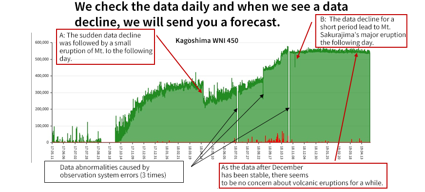
The following shows volcanic eruption predictions for Mt. Kirishima and Mr. Sakurajima based on the data collected at the observation points in Kagoshima:
The graph shows electromagnetic noise for the 2-year period, collected at the observation points in Kagoshima as of May 1, 2019. The large “wall-shaped data” in the graph indicates that electromagnetic noise was generated by an increasing amount of pressure caused by magma pooling underground.
As shown in A, on April 18, 2018, the data decline was observed, and Mt. Io had a small eruption the following day.
In addition, as shown in B on November 12, 2018, the data showed a decline for a short period. Then Mt. Sakurajima had a major eruption on November 14, 2018.
It is believed that when the cap of the magma pool shifts (melts), the internal pressure of the magma chamber decreases, causing the data to decline. Meanwhile, magma escapes the chamber, reaching the earth’s crust in one to two days, resulting in an eruption.
We check the data daily and when we see a data decline, we will send you a forecast.
Our sincere sympathies to those affected by the 2014 Mt. Ontake eruption.
The “Reverse Radio” electromagnetic noise earthquake prediction system, which was researched and developed by our company, not only predicted the Great East Japan Earthquake on March 11, 2011, but also showed precursory electromagnetic noise a few months before large earthquakes happened.
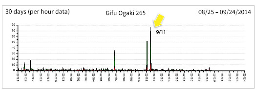
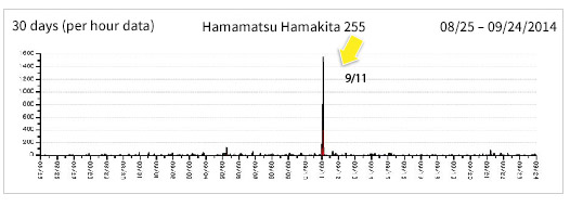
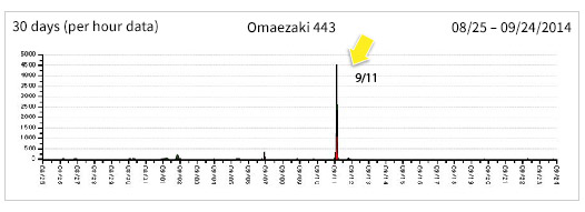
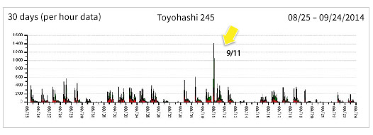
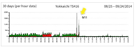
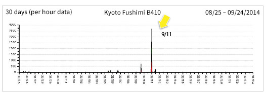
Such precursory noise was the collection of bar-shaped noise data that was observed at 9 different observation points in a wide range of areas from the central to the western parts of Japan (Tokamachi in Niigata, Ogaki in Gifu, Hamakita in Hamamatsu, Omaezaki, 2 locations in Toyohashi, Fushimi in Kyoto and Kobe)16 days before the eruption of Mt. Ontake on September 11.
We later found out that on September 11, the day on which the bar-shaped data that was collected synchronously in a wide area, there were 85 volcanic earthquakes caused by Mt. Ontake in one day, recording the largest number of earthquakes in the past few years.
Although this doesn't go so as far as to prove that the volcanic eruption was forecasted, we saw the number of volcanic earthquakes hit a record high on the same day as electromagnetic noise data surrounded the Gifu region.
We believe that there must be a strong possibility that this was some kind of precursor to the eruption such as underground magma movements, etc.
We will strive to continue our research and development efforts in seismic studies as well as strengthen and increase observation points for the pursuit of reducing the impact of mega earthquakes such as the Great East Japan Earthquake and many volcanic eruptions.
Mt. Ontake Eruption Information
Information released by the Japan Meteorological Agency on September 27, 2014
A volcanic eruption of Mt. Ontake (border between Nagano and Gifu Prefectures) took place at 11:53AM on September 27, 2014 (Sat).
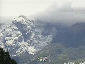
(Material: Image. 2 Mt. Ontake eruption)
The mountain had not had any eruptions since a small-scale eruption that occurred at the end of March in 2007. It was the first time that the volcanic alert level was raised to Level 3 since they introduced the volcanic warning system for Mt. Ontake on March 31, 2008.
▼The Japan Meteorological Agency
“Mt. Ontake Volcanic Eruption Occurred on September 27 - The volcanic alert level was raised to Level 3 (entry restrictions)-”
The Japan Meteorological Agency Homepage
Information Released by the Japan Meteorological Agency on September 28, 2014
Extracted from the article released by the Coordinating Committee for Prediction of Volcanic Eruptions.
The very first volcanic eruption of Mt. Ontake occurred in 1979, then smaller-scale eruptions occurred consecutively in 1991, then in 2007. Since then, although the volcanic activities of the mountain had been thought to be dormant, the number of volcanic earthquakes whose epicenter was around the summit of Mt. Kengamine increased temporarily around the 10th and the 11th of September this year, and low-frequency earthquakes had occasionally been happening since the 14th. The number of volcanic earthquakes gradually decreased. There were no remarkable changes to the plate tectonics or fumarolic activities around the summit area. The precursory changes before the eruption were relatively small compared to those of the small-scale earthquake which occurred in 2007.
52 volcanic earthquakes occurred on September 10, and 85 volcanic earthquakes occurred on September 11.
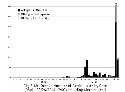
Compared to the eruption in 2007, the volcanic eruption this time was a collection of small seismic activities.
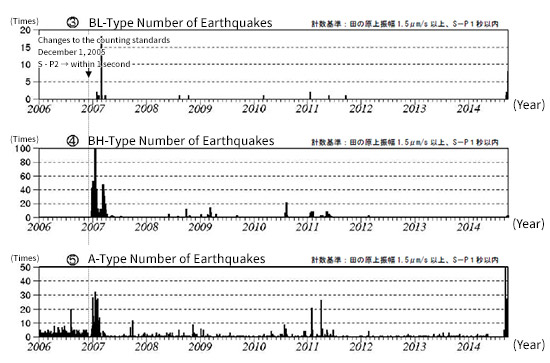
Fig. 8 Mt. Ontake Number of Earthquakes by Date, Fig. 11 Mt. Ontake Trends in Recent Volcanic Activities
▼The Japan Meteorological Agency
“Mt. Ontake Volcanic Eruption Occurred on September 27 - The volcanic alert level was raised to Level 3 (entry restrictions)-”
The Japan Meteorological Agency Homepage
Mt. Ontake Eruption Prediction Data
Our company collects electromagnetic noise data daily from all Reverse Radios installed at the more than 100 observation points located throughout Japan. When data anomalies are detected, earthquake warning information is sent out to the managers of the observation points (and cooperative companies) and the members of “Yurekurun,” earthquake prediction information distribution service.
FREE TRIALElectromagnetic Noise Appeared Synchronously at Several Observation Points
On September 11, the observation points located in a wide area from the central to west parts of Japan showed electromagnetic noise synchronously.
<Observation points that showed electromagnetic noise>
Ogaki in Gifu, Hamamatsu, Omaezaki, 2 places in Toyohashi, Yokkaichi, Fushimi in Kyoto, Nada in Kobe, Tokamachi in Niigata.
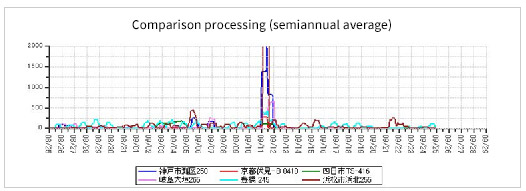
Normally, the wide range of synchronized data (bar-shaped noise) suggests that it could be a “prediction for a large earthquake.” The trends show that large bell-shaped noise data could also appear at several places synchronously.
However, no bell-shaped data appeared at any of the observation points, but bar-shaped noise data that had not been seen before mysteriously appeared this time.
Remarks:
Synchronous data appeared in a wide area from the Tokai Region to the Kansai Region around September 11, 2014.
The observation points were Ogaki in Gifu, Hamakita in Hamamatsu, Toyohashi, Yokkaichi, Fushimi in Kyoto and Nada in Kobe. It is very rare to see synchronous data that covers such a wide area from Hamamatsu to Kobe.
▼Gifu Ogaki 265 Observation Point
▼Hamamatsu Hamakita 255 Observation Point
▼Omaezaki 443 Observation Point
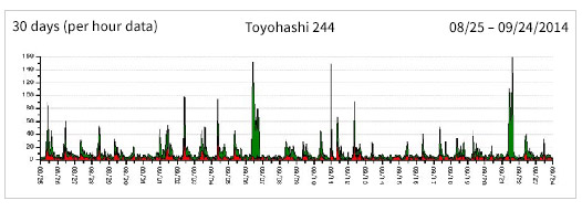
▼Toyohashi 244 Observation Point
▼Toyohashi 245 Observation Point
▼Yokkaichi TS416 Observation Point
▼Kyoto Fushimi B410 Observation Point
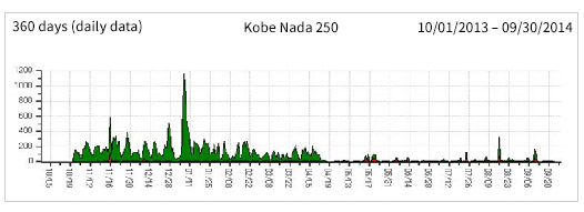
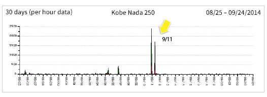
▼Kobe Nada 250 Observation Point
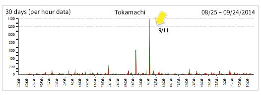
▼Tokamachi Observation Point
▼Ratio (Nada in Kobe, Fushimi in Kyoto, Yokkaichi, Ogaki in Gifu, Toyohashi, Hamamatsu)
▼Ratio (Tokamachi, Hamamatsu, Omaezaki, Toyohashi 244, Toyohashi 245, Yokkaichi)
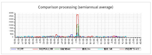
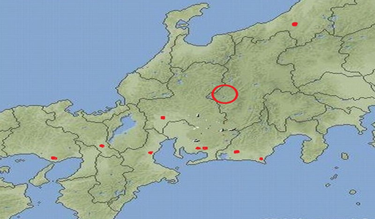
When several observation points show synchronous noise data, the center of the locations that are farthest apart is usually suggested as an approximate epicenter. The map showed the center would have been somewhere between Gifu and Lake Biwa when the observation points were all laid out.
However, we refrained releasing this information as there were no outstanding data anomalies at any of the observation points near these locations; thus, it was difficult to determine there was going to be an earthquake.
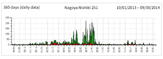
▼Nagoya Nishiki 251 Observation Point
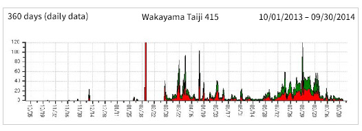
▼Wakayama Taiji 415 Observation Point
▼Kobe Nada 250 Observation Point